GPS/Combo/Fish finder Samyung N560 (Demo)
The Samyung N560 GPS Plotter is a high-performance navigation device designed to enhance maritime navigation with advanced GPS and chart plotting capabilities. With a focus on accuracy, reliability, and ease of use, the N560 GPS Plotter is ideal for recreational boaters, professional mariners, and anyone in need of accurate navigation information while on the water. This device offers a range of features that make it an essential tool for route planning, real-time navigation, and ensuring safe and efficient voyages.
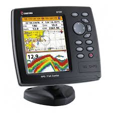
The Samyung N560 features a large color display that shows detailed charts, routes, and real-time positioning, and is equipped with advanced GPS technology for precise location tracking. It also supports multiple types of maps and has the flexibility to integrate with other marine equipment, such as radar, depth sounders, and fish finders, providing a comprehensive navigation solution.
High-Performance GPS:
The Samyung N560 features a built-in GPS receiver with high accuracy, allowing for precise position tracking and navigation.
Supports DGPS (Differential GPS) for enhanced location accuracy, providing real-time position updates and reliable navigation information.
Large Color Display:
The N560 comes with a bright, easy-to-read color display (typically 5" to 7" size) that clearly shows your current position, routes, waypoints, and chart details.
The display is designed for easy viewing in various lighting conditions, making it ideal for use in direct sunlight or at night.
Electronic Chart Display and Information System (ECDIS):
The Samyung N560 supports ECDIS functionality, allowing it to display navigational charts and information in a user-friendly format.
The plotter supports various types of electronic charts, including C-Map and Navionics, providing flexibility for different maritime regions.
Route Planning and Waypoints:
The N560 allows users to plan routes in advance and store multiple waypoints for easy navigation. It helps you plot courses based on your current position and destination, guiding you along the safest and most efficient paths.
Route simulation features help in testing and adjusting routes before setting sail.
Real-Time Navigation:
The device provides real-time navigation with accurate positioning, helping users stay on course and avoid obstacles.
It offers features like course over ground (COG), speed over ground (SOG), and cross-track error (XTE), ensuring continuous, precise navigation.
GPS and Navigation Data Display:
The Samyung N560 displays vital navigation data, such as latitude/longitude, course and speed, and time to destination, in a clear and concise format.
You can also customize the display to show additional information such as tides, current conditions, and other environmental data.
Multi-Function Compatibility:
The N560 can be integrated with other marine electronics such as depth sounders, radar, autopilots, and AIS (Automatic Identification System), offering a complete navigation solution.
Integration with radar allows for enhanced situational awareness, especially in poor visibility conditions.
Customizable Alerts and Alarms:
The device features customizable alarms, including proximity alarms for waypoints, anchor alarms, and cross-track alarms, ensuring you are always aware of your position and any potential issues on your route.
Durability and Waterproof Design:
Built to withstand harsh marine environments, the Samyung N560 GPS Plotter has a waterproof and rugged design, ensuring reliable performance even in adverse weather conditions.
The device meets the necessary IP rating for protection against water and dust ingress.
User-Friendly Interface:
The N560 features an intuitive interface with straightforward menu options and touchscreen or button controls (depending on model), making it easy to use even for less experienced users.
The system supports multi-language options, making it accessible to international users.
Applications:
Recreational Boating: Ideal for private boaters and anglers who need reliable GPS navigation and route planning features on the water.
Commercial Vessels: Suitable for professional mariners and commercial ships that require accurate navigation, chart plotting, and situational awareness.
Cruising and Sailing: Perfect for sailors who need to plan long-distance routes and navigate safely through coastal waters and offshore environments.
Fishing and Expedition: Can be integrated with fish finders and other marine sensors to provide a complete navigation and fishing solution.
Why Choose the Samyung N560 GPS Plotter?
Accuracy: High-performance GPS ensures precise positioning and accurate navigation.
Flexibility: Supports various electronic charts and integrates with other marine electronics for a comprehensive solution.
User-Friendly: Easy-to-navigate interface and clear display make it simple to use for all levels of boaters.
Durability: Waterproof and rugged design makes it suitable for use in harsh marine conditions.
Documents
Barcode:
34.5.4.1.16
Producer:
Samyung ENC